Bunbury Parish Council’s response to the Parkside Appeal
(Click on the document first, and then you can scroll through it.)
Appeal on Parkside Campaign message:
Many residents were no doubt surprised to receive notification of an appeal against the decision by Cheshire East to refuse planning permission on 28 June 2023 for 20(25) First Homes (22/4203N). This site has a long history of refusals of applications to build on the field at the rear of houses on the west side of Bunbury Lane. Surprised because the 6-month time limit for registering an appeal was well passed. So, why is an appeal allowed now? The HM Inspectorate of Planning appears to be another public service that cannot operate at acceptable service levels. Staff shortages, underfunding? That needs to be clarified, but the result is a significant backlog of cases waiting for adjudication. Apparently, an appeal was lodged back in November by the appellant’s agent, but this was placed in the queue and has only now come forward for consideration.
You have until 23 April to have your say:
Please object to the Appeal on the Planning Inspectorate Website at:
https://acp.planninginspectorate.gov.uk, or by letter in triplicate to the: Planning Inspectorate, Temple Quay House, 2 The Square, Temple Quay, Bristol, BS1 6PN quoting the Appeal Reference APP/R0660/W/23/3332521. See below for step-by-step guide on completion.
Objections must be received by 23 April 2024
Please help protect our green spaces, other greenfield sites across the village could be vulnerable to development if this Appeal is granted.
Grounds for objection could include:
Open Countryside and Cheshire East Local Plan
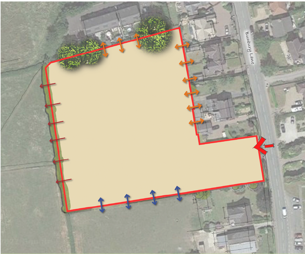
The Appeal site runs directly along the back of houses on Bunbury Lane, outside the settlement boundary. Contrary to the Appeal Statement, the site forms an important part of the open countryside leading out of the village. Since 2014, the site has been the subject of two previous applications, both of which were refused and ultimately dismissed at appeal. The importance of the open countryside allocation in this location was made clear in the two previous appeal decisions.
The proposal seeks to develop up to 25 dwellings on the site, which is meant to be protected from development by policy PG6 (open countryside) of the Cheshire East Local Plan. Policies stand in the way of development in the open countryside, as in breach of policy, the development would undoubtedly (however well laid out, landscaped or mitigated) not protect the character and appearance of the open countryside.
National Planning Policy Framework
The appellant is presenting the development of the site for ‘First Homes, ‘ which are defined in the latest version of the National Planning Policy Framework (NPPF) as ‘entry-level exception sites.’ The ‘exception’ for the First Homes exception site is only allowable if the Authority (Cheshire East, in this case) is not meeting this need elsewhere.
Cheshire East Council has in excess of a 5-year supply of housing, including affordable housing, and the SADPD has defined a settlement boundary for Bunbury and states in policy PG8 that ‘it is expected that the housing element of the policy will be addressed by windfall going forward, in line with other policies in the Local Plan.’ The proposals do not align with policy PG6 or NP policy H1 as they involve harm to an important part of the ‘open countryside’ for Bunbury.
Bunbury Neighbourhood Plan
Bunbury has a ‘made’ Neighbourhood Plan and the proposed site is outside the settlement boundary.
Number of Houses already built or approved since 2010
Policy H1 of the Neighbourhood Plan states that planning permission will be granted for a minimum of 80 houses to be built in Bunbury in the period from April 2010 to March 2030. To-date 110 houses have been built or approved, including 35 affordable dwellings. Therefore, Bunbury is delivering on its housing commitment to meet local need and no further large sites of development are required during the Plan period to March 2030.
Size of developments
Policy H2 and H3 of the Neighbourhood Plan limit the size of developments to a maximum of 15 and should not be co-located with other new housing developments. This application is for 25 houses and so is not compliant with the policies contained within the Neighbourhood Plan.
The National Planning Policy Framework is clear that where a planning application conflicts with policies in an up-to-date Local Plan or Neighbourhood Plan, the application should not be granted.
First Homes and demonstration of Need
Under transitional arrangements, Local Plans and Neighbourhood Plans adopted before the date of the Written Ministerial Statement of 28 June 2021, as Bunbury’s was, are not required to adopt the First Homes policy.
No evidence of a need for a First Homes scheme in this location has been provided. A letter from Minister of State for Housing and Planning to Edward Timpson, MP, dated 7 August 2023, states, ‘ it is the responsibility of applicants to provide the necessary evidence to support their planning applications’ and ‘First Homes should be built on sites where an affordable housing need has been established.’
Location
Exception sites should be close to employment, services and facilities. Bunbury is very limited in all of these, as identified by the Inspector when he dismissed the Appeal in April 2022. It is clear that any occupants of the development would be wholly reliant on the private motor vehicle due to the lack of sufficient and regular public transport. Bunbury only has a bus service to Nantwich for two hours a day, six days a week, so there is no public transport for work purposes.
Planning Balance
Section 38(6) of the Planning and Compulsory Purchase Act 2004 states that development should be in accordance with the development plan unless material considerations indicate otherwise (the planning balance). The adverse impacts of allowing development that conflicts with the Neighbourhood Plan and Cheshire East Local Plan would significantly and demonstrably outweigh the benefits of allowing the development on this site. This application conflicts with the development plan as it is in open countryside, outside the settlement boundary, it is for 25 dwellings and would result in a cramped development of one type of housing, it would impact upon the character and appearance of the immediate area and be unsustainable.
There are no strong material considerations in this appeal to depart from the policies in the Local and Neighbourhood Plans.
For more information contact Isabel Noonan – 07973917518 or email imnoonan3@gmail.com
Thank you for your past and continuing support
Step-by-Step guide to submitting an objection:
1. Click on the government address in the notification letter or above, this will take you to the relevant website. Enter 3332521, the last seven numbers of the case reference in the ‘search for a case’ box.
2. Click ‘Submit Search’
3. The case details will appear, click ‘Make Representation’
4. Further case details appear. Click on ‘Save and Continue’
5. Make representation page appears, click on one of the choices for your details i.e Interested Party/Person
6. Click on ‘Save and Continue’
7. Make Representation page. Fill in type of representation and then click either ‘the box below’ if you are going to type your objections or ‘separate documents’ If you wish to attach a document. You can cut and paste your original text if you have it, amended as required, into the text box.
8. Click ‘Save and Continue’
9. Tick ‘Confirm’ box
10. ‘Submit’
11. ‘Continue’
Update (January 2024)on Methodist Chapel Development:
Application 23/3662N New four bed dwelling off Hurst Close adjacent to the car park.
This has now been given consent as of the 11/01/2024. The Planning officer has listed some specific conditions as the dwelling will sit in the Lower Bunbury Conservation zone. This house occupies part of the site on which, previously, the developers attempted to build two properties.
During the consultation period the Parish Council made a strong case for refusal but the Planning Officer did not find merit in their comments.
Subsequently, the Developers have now submitted a new application 23/4819N for the demolition of the Chapel and replacing it with a four beded house.. However, it appears this part of the site is also for sale, presumably with the planning consent their application seeks, but possibly not.
New Developments at Oak Gardens (December 2023)
Land at Oak Gardens, Bunbury CW6 9QN
Proposal
Variation of condition 1 on application 19/5534N.
This proposal seeks to rewrite the plans agreed under the consent conditions of 19/5534N. To make the point for those who don’t follow these matters closely, these are the plans that the developer wants or could change if successful in their application:
Site plan
Landscaping plan
House type D3 1418-
Tree protection plan
Drainage layout
Land drainage consent
Site section
External works plan
House type F2
House type B
19/5534N/PDN1Rapcon(CE)
Lighting plan
House type A
House type E
Location plan
Levels
House type F
You will note the list is very specific in its reference to which plans are agreed and covers all the reserved matters. That process started in 2016 and concluded in 2019. We are nearly at the start of 2024, and the developers now seem intent on starting again! Well, it’s not a complete clean slate job, but let’s look at what they want to do.
1. Removed the Veteran Ash (T5 on their new plans).
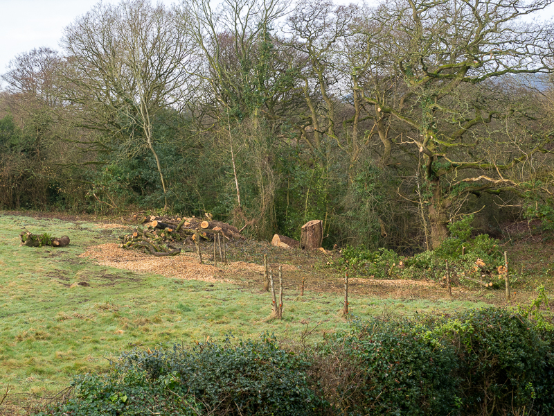
The tree has long been a bone of contention with the developers and is one reason the site is not a straightforward greenfield site. Much of the layout has been strongly influenced by the need to avoid the Ash to protect it and its roots. The status of ‘Veteran’ is awarded to trees of advanced years but with at least 40 years remaining. It is an A3 category tree – the tops. Its value is not just in its survival but in the rich biodiversity that such trees support. Like all old trees, it has some cracks – older trees are prone to these – but the benefit is that it is an excellent refuge for bats, birds, etc. The field is surrounded by protected trees and has a protected wood along its western boundary – another source of difficulty for the developers.
The reason, therefore, for the planned removal is apparent. It opens up a new space into which the builders can move a house from the west end of the site and move into the middle along the northern boundary and, simultaneously, increase the size and profit of other homes on the site.
The arguments for doing this and other work on the Protected Trees surrounding this site are contained in a new Arboricultural Impact Assessment (AIA). But it doesn’t actually say why the tree should be removed other than it’s old. The AIA makes no claims on the grounds of safety as it says it is not authorised or competent to make such an assessment given the basic nature of the survey. It refers to a previous document where it was agreed to take the tree out, but that is not available, and curiously, the AIA has now also disappeared from view! That should be enough to stop the application. All the new plans rely on the removal of the tree.
2. Increased size of some properties
The houses up for sale have now been able to increase their floor plans. As we all know, in the world of commercial house building, ‘Big is Best’, or the cost per M2 falls as the dimensions increase and the selling price rises.
3. Shrinking affordable homes:
Not only do the trees on this site have to pay the price of expanding properties, but the affordable homes have now shrunk to make more room available– so far have they shrunk that they can no longer meet national ‘Space Standards’ (NDSS). All 4 of the affordable dwellings are below the minimum gross internal floor stated in the NDSS. The CE housing department has noted this and lodged an objection.
4. Protecting the houses from the trees
The purpose of assigning protection status to trees and woodlands is to, well, ‘protect them’. Early on in the history of the development of this site, this was clearly present in the statements of the relevant officers. The initial response was to have a buffer zone along the western boundary to protect the woodland. The Veteran Ash was to be protected and its roots not impinged on. You can see the contrast in the process by noting the comments of the Inspector who granted the appeal back in 2016 and then seeing what happened:
26. I understand that the application site falls within an indicative wildlife corridor as shown in the NP. The NP recommends a 15m non-developable buffer zone adjacent to the wildlife corridor. The Council has acknowledged that this appears to have been achieved in the indicative layout, and I have no reason to find otherwise.
Appeal Decision APP/R0660/W/16/3165643
However, the buffer zone had gone by the time the reserved matters were agreed on in application 19/5534N. As you can see in the photo below, the ‘Protected Woodland’ was pushed back and made ‘safe’ for the houses.

If we had access to the new AIA, we would see that they plan further work on the trees, suggesting in some places that coppicing should take place, a drastic method of ‘control’ that involves cutting a tree down to ground level. On which trees this method is to be inflicted and what other plans they have fo
What happened in the field next to Oak Gardens and why it matters
Why was a protected woodland damaged and its associated buffer zone removed despite clear guidance from Cheshire East Officers to protect it, the HMI who noted the same, the Parish Council who sought respect for the Neighbourhood Plan, and numerous residents who demanded that the protection be established.?
From the start, the issue was clear. The Neighbourhood Plan puts the position clearly
..a ‘Bunbury Wildlife Corridor’ which follows the route of the River Gowy and its tributaries. We recommend that the corridor is identified in the Neighbourhood Plan and is protected from development.
…we suggest that an adjacent non–developable buffer zone is identified. The buffer may be in the region of 15 metres in order to fully protect high value habitats. Bunbury Neighbourhood Plan 2016 page 32 – Biodiverity Project)
It was identified in the plan but was not protected.
Cheshire East Officers were also well aware of the situation when reviewing the initial plan:
James Baggaley, Principal Nature Conservation Officer 2016, wrote:
The Woodland on the site…. appears on the national inventory of Priority Woodland habitats. Habitats of this type are a material consideration. The Woodland edge extends into the site beyond the existing fence line boundary. I note that the revised layout plan shows a retained area of Woodland excluded from the gardens of the proposed development. This area does not, however, extend to the full extent of the tree canopies of the adjacent woodland trees and so in my opinion, is unlikely to be adequate to maintain the edge habitats of the adjacent Woodland. I recommend that the submitted illustrative layout plan be amended to show an area of standoff from the adjacent Woodland.
Chris Hudson Environmental Planning Officer in response to the application in 2016, makes much the same point:
‘..the indicative design (see below) and position of certain plots are dictated by the position of the access and that the potential loss of protected Woodland to domestic garden has not been adequately addressed in the submission.
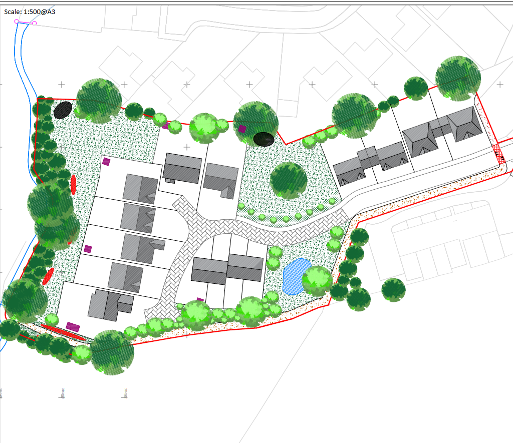
In response to these points, the developer proposed the following site layout (below) The top of the site is north, and you can see a buffer zone (of variable width) between the gardens along the western edge and the woodland. The red and black ‘blobs’ are ecological mitigation’ features added reduce the damage to wildlife.
Cheshire East Officers were also well aware of the situation when reviewing the initial plan:
In his report, the HMI who gave consent makes this comment in paragraph 26:
I understand that the application site falls within an indicative wildlife corridor as shown in the NP. The NP recommends a 15m non-developable buffer zone adjacent to the wildlife corridor. The Council has acknowledged that this appears to have been achieved in the indicative layout (above)and I have no reason to find otherwise.
Appeal Decision APP/R0660/W/16/3165643
However, the Inspector did not make this protection scheme a condition of the consent. Such details were best settled at the ‘Reserves Matters’ phase of the application once outline permission was granted. Was this the turning point when the damage to the woodland became possible?
The full history is too complex to go into in detail. There were further refusals of applications and a couple of withdrawn applications. We can see the Woodland starts to come under pressure from the comment made by the Principle Landscape Architect – James Gomulski in application 18/6338N:
The Revised Indicative Layout drawing provided a 15m non-developable buffer zone, as recommended in the Neighbourhood Plan. Not only has this buffer been reduced, but appears to be an informal extension of the rear gardens.
You can see this in the next site plan:
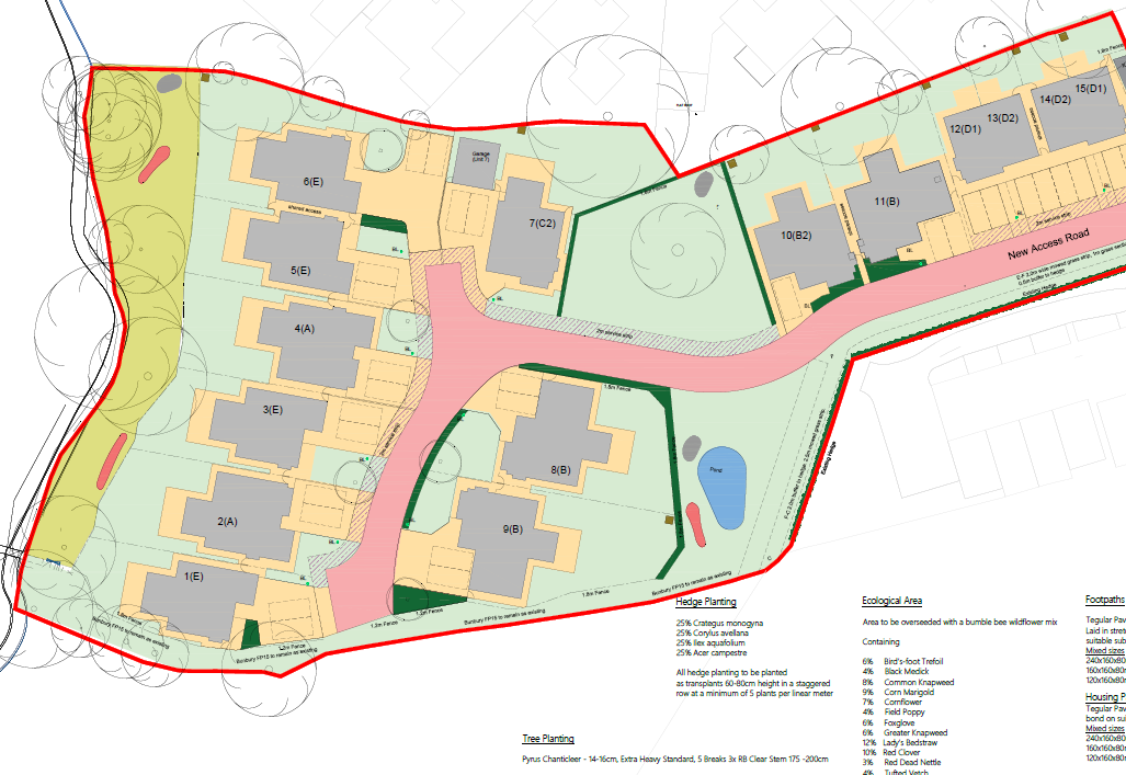
Note that the buffer zone has gone. But all the trees are shown as present. However, after the first deadline on application 19/5534N had expired (25/12/2019) , it was extended and a series of new documents were listed on the planning website. Thiese included
a new tree survey (a previous one was included in the initial application) that now identified the Large Ash tree as needing to be removed ‘…to provide working space for external works .’ because of ‘…Minor ingress within the outer section of the root protection area.’
(ARBORICULTURAL IMPACT ASSESSMENT AND METHOD STATEMENT Revised March 2020)
Just to make it clear, the last landscape plan (above) is listed (15/04/2020) after the documents identified significant changes to that landscape on 1/04/2020. What was intended was this:
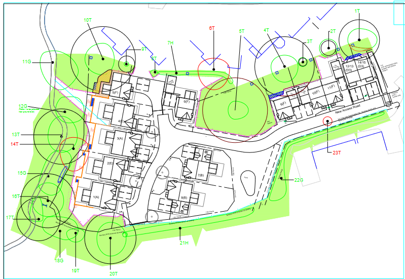
The red circle highlights the ash tree 14T and the fallen oak 6T canopies, and the black circles the root protection area.. Other tree canopies are shown in green. Note that tree 6T fell over in a storm and was therefore removed by natural forces.
The Woodland on the site…. appears on the national inventory of Priority Woodland habitats. Habitats of this type are a material consideration. The Woodland edge extends into the site beyond the existing fence line boundary. I note that the revised layout plan shows a retained area of Woodland excluded from the gardens of the proposed development. This area does not, however, extend to the full extent of the tree canopies of the adjacent woodland trees and so in my opinion, is unlikely to be adequate to maintain the edge habitats of the adjacent Woodland. I recommend that the submitted illustrative layout plan be amended to show an area of standoff from the adjacent Woodland.
The reserved matters process had seen the elimination of the buffer zone and cutting back of the Protect Woodland. We might have expected the CE officers to protect the woodland and associated trees. That did not happen, and the consequences can be seen by anyone walking around the field and in the above photo.
The development was allowed to creep into the buffer zone, as can be seen in the final layout provided by the developers. Healthy trees are cut down and cut back to ensure the houses along the western edges are not in their shade. At the start, the argument ran in the opposite direction, keeping the houses back so the woodland and wildlife are protected and left relatively undisturbed. Why the change?
-

This is an excellent piece of work. In the matter of contentious planning approvals, have you seen the granting of approval for solar panels to be be fitted to the roof of a Grade II listed property in Higher Bunbury Conservation area? Application 23/4481N. This was despite objections from Heritage and I am told PC although it has not appeared on the portal. This sets a precedence for similar developments in the conservation areas.
The Planning Application on the Methodist Chapel plot:
Planning Application 22/5061N
The full planning proposal is to construct two neo-Georgian-style four-bed houses on the site of the Methodist chapel at the junction of Hurst Close and Bunbury Lane. Unfortunately, as are several other required documents, no Design and Access Statement is available. So we are left with only the plans for the two houses. The site plan is below:
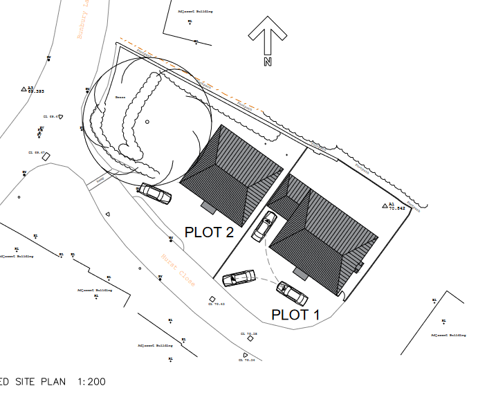
Plot 1 & 2
Show large neo-Georgian style buildings with nine windows to the front and eight windows plus over half the rear ground floor elevation with some full height glazing – opening presumably onto the small back garden.
We have four bedrooms, three bathrooms and a dressing room upstairs.
The only difference with plot 2 is that it currently lacks a garage.

Commentary:
This application quickly follows the sale of the site. Haste, as will hope to show, is one of the unwelcome characteristics of this proposal. To be clear, we are open to developing this site for housing. But it is within the conservation zone of lower Bunbury and in the proximity of a grade 2 listed cottage across the road. The site offers excellent potential for dwellings designed in sympathy with the surrounding area and able to contribute to dealing with the actual housing needs of the village. However, this application fails these two tests. Firstly the designs have all the sensitivity of a poke in the ribs. Did the designers look at the Village Design Code? Were they aware of the conservation zone in which they intended to place these dwellings? The results of their efforts suggest not. One might think that they looked around for an ‘oven-ready’ solution that pleased the developer and plonked it into the application after some minor alterations. Unfortunately, we have no Design & Access Statement or material to justify their choices (at the time of writing), so we are left to speculate as to how they came upon such a poor choice for this site. As far as I am aware, Bunbury has no historical example of Georgian-style properties within the village. Yet we are presented with two neo-Georgian style houses entirely out of keeping for this village.
They are also large for the site they occupy. Houses mainly fill both plots with frontages designed for cars and small rear and side gardens. These rear areas will be rather dark as they face NE, are narrow, and will be in the shade for much of the day. A human concern but not a planning issue. But what is, is the potential overshadowing of the house to the NE, which will have their garden put into the shade by the erection of these two large houses just to the south.
Further, the size of plot 2 property encroaches onto the root area of the protected walnut tree immediately to the N of the side elevation. It will have to move.
In conclusion, this application is for the wrong size and style of house in this location. They are too large for the site, over-shadow to the north, and over-dominate the cottage style of dwellings in the area. The applicant must respect the area’s specific context or the housing style most appropriate for this site. I agree, therefore, that this is an inferior application. Usually, developers try to respond to our Neighbourhood Plan and Village Design Code (both about to be updated with important modifications). But not in this case. This application suggests haste, and the need for a more sensitive plan is clear.
r other trees, I cannot say as the tree Impact Assessment has been removed.
Give your comments on the Cheshire East website HERE. You have until the 3 January 2024
Update:
Developers refused the application on the Parkside site yet again:
For the third time in 7 years, an application (22/4203N) has been refused. This was an unusual application that was supported by the Planning Officers and therefore significantly raised the stakes. The unusual nature of the application was that it was presented as an ‘exceptional site’ under a new Government scheme to promote first-time house purchases – hence the scheme title ‘First Home’.
The developers argued that under the scheme the ‘exceptional’ rules attached to this new scheme would allow it to sit outside the settlement boundary for Bunbury in open country. Further, they could put 25 homes on the site as the Bunbury Neighbourhood Plan, with its restriction of 15 homes as the maximum acceptable number on anyone site also did not apply. This produced an application that gave no details of the design of the dwellings to be built, which conflicted with a number of existing Policies from Cheshire East and our Neighbourhood Plan. Despite this serious multitude of failings, it was recommended for consent a the planning committee last Wednesday.
It failed. And it did so as a result of those conflicts with planning policies and the excellent presentation given by the Bunbury Parish Council (Andrew Thompson – Vice Chair of the PC) and Isabel Noonan on behalf of local residents.
This was a long session for a planning application before the committee of nearly one and a half hours. The Planning Officers were clearly committed to the need for such a site and had selected Bunbury as a test case for Chesire East. While it failed, it was clear that this was just the start. A number of points against the application could be dealt with in subsequent applications:
Reduce the number of dwellings to 15
Provide clear design information for the site and the houses
Have available a up-to-date ‘Housing Needs Survey’ that actually has evidence to support the construction of such a site
Provide a better social mix of housing to avoid grouping new homeowners on one large site.
There were other issues relating to the relationship between new government initiatives and existing Local Plans that need resolving at a ministerial level. These may take some time, and we may have a change of government meanwhile, but the challenge to build on greenfield sites around Bunbury is very likely to continue
Planners ready to say ‘yes’ to another greenfield development in Bunbury
Update on Parkside ‘First Homes’ application
Cheshire East is recommending the approval of the application for up to 25 First Homes on a greenfield site at Parkside off Bunbury Lane.
Update June 21
- This development is contrary to Cheshire East’s own Local Plan
- This development is contrary to the Bunbury Neighbourhood Plan
- There were over 130 local people, including you, who objected online to this proposed development in December 2022.
Many residents have written to our local representatives, MP Edward Timpson and Cheshire East to express their anger and strong opposition to this application.
Despite this, Cheshire East is set to recommend that it is allowed to go ahead.
Now our only course of action is for as many local residents as possible to attend the Planning Committee in person.
We need your support
Please join us at the Planning Committee on 28 June to show the Council our strength of feeling against this development.
10am Wednesday 28 June 2023
Council Chamber, Municipal Buildings,
Earle Street, Crewe, CW1 2BJ
Thank you for your support – Bunbury Neighbourhood Plan Steering Group
For more information – Andrew Thomson – 07884316105, andrew@thomsonplanning.net or
Isabel Noonan – 07973917518, imnoonan3@gmail.com or https://bunburyvillage.info
Original post on this issue:
Planning Application – Ref:22/4203N – Parkside, Bunbury Lane, Bunbury, CW6 9QZ
- This development is contrary to Cheshire East’s own Local Plan
- This development is contrary to the Bunbury Neighbourhood Plan
- There were over 130 local people, including you, who objected online to this proposed development in December 2022.
Bunbury Neighbourhood Plan Steering Group feel strongly that the Cheshire East Planning Committee members have not been fully informed about the reasons why this application should be refused.
The application was due to go to the Cheshire East Southern Planning Committee on 31 May but this was cancelled. A new date has yet to be announced but it is likely to be before the end of June.
If this application is approved, it would set a serious precedent across the whole of Cheshire East for First Homes in open countryside outside settlement boundaries. This recommendation undermines the entire principle of neighbourhood planning and goes against the very clear advice in Government guidance.
The formal objection process is closed, but we are asking you to e-mail (include your address) as a matter of urgency your opposition once again to:
Case Officer – Gareth.Taylerson@cheshireeast.gov.uk
Ward Councillor – becky.posnett@cheshireeast.gov.uk
Your MP – edward.timpson.mp@parliament.uk
These are the reasons why we are objecting. You can use these in your e-mails:
- The Council report does not take into account the planning history on this site – two previous applications refused and two previous Appeals dismissed, one less than a year ago. The recent Appeal decision is not drawn to members’ attention in the Committee report – why is this?
- The Council report does not state that the application site is in open countryside and is protected by policy PG6 of the Cheshire East Local Plan. The description of the site as ‘predominantly residential’ by officers in the report is not correct – there is frontage development onto Bunbury Lane but the site is almost entirely open countryside, outside the settlement boundary
- Cheshire East Council accepts that the proposal is contrary to the Bunbury Neighbourhood Plan as the number of dwellings would exceed the agreed threshold of 15 houses on any one site (policy H2). It would also be co-located with another consented development (policy H2). The Council accepts harm would be done through co-location and a higher concentration of properties in this part of the village. Nevertheless, they still recommend approval, undermining the Neighbourhood Plan process and local democracy.
- The policies in the Bunbury Neighbourhood Plan limiting the size of developments to a maximum of 15 and the co-location policy have already been supported by Cheshire East in previous planning applications and appeals in Bunbury.
- Bunbury has already delivered 108 houses built or approved in the past 12 years, including affordable houses. This is well over the minimum of 80 stated in the Neighbourhood Plan.
- The report argues that the Government’s new First Homes policy comes into play. This is not correct. The First Homes requirement does not apply the Neighbourhood Plans made before 28 December 2021 as Bunbury’s was. The First Homes initiative does not apply in Bunbury as we have a made Neighbourhood Plan.
- There appears to have been recent negotiation between Cheshire East and the applicant to reduce the number of houses from the original 25 proposed to 20. There is no public record of correspondence on the application web site between the applicant and the planners. Where is the transparency on decision making with this application?
- Cheshire East is arguing that the proposed development is suitable as a First Homes exception site. The applicant has provided no housing needs survey to justify the use of this greenfield site in this way. The definition is that exception sites should be close to employment, services and facilities. It is likely, as noted by the Appeal dismissal (April 2022) ‘that most occupiers of these additional homes would have to travel outside the area by car to access the majority of these facilities’. Bunbury has very limited bus services and employment opportunities.
PLEASE WRITE e-mails as suggested overleaf and please tell your neighbours about the situation. As you have already objected to this application, we will let you know the new date for the hearing of this application. To show the strength of local opinion against this application we are asking as many people as possible to attend the meeting at Crewe Council Chamber. Please join us if you can
Thank you for your support – Bunbury Neighbourhood Plan Steering Group
For more information – Andrew Thomson – 07884316105, andrew@thomsonplanning.net or
Isabel Noonan – 07973917518, imnoonan3@gmail.com
greenfield development in Bunbury
This is an excellent piece of work. In the matter of contentious planning approvals, have you seen the granting of approval for solar panels to be be fitted to the roof of a Grade II listed property in Higher Bunbury Conservation area? Application 23/4481N. This was despite objections from Heritage and I am told PC although it has not appeared on the portal. This sets a precedence for similar developments in the conservation areas.